Meet Ramsey Junior

Hi

I haven’t posted for a while because my van life has been in transition. I traded Ramsey, my fully-stocked 21-foot Class B that got 14 miles per gallon, for a small cargo van that fits in my garage and (supposedly) gets 28 miles per gallon on the open road.

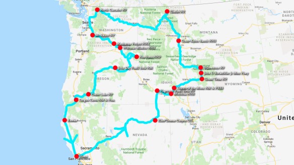
I made the decision to make the swap after taking a trip around the Northwest last August. As you can see from this map, I visited many National Park sites. What a treat that was!

2019-Aug-Map-NorthwestNatParks

But on my way home I was wishing I didn’t burn so much fossil fuel while enjoying the scenery. I was coveting smaller vans. Driving Ramsey around for two years taught me what I need and what I don’t.

  • I never used Ramsey’s shower.
  • I only need one burner on the stove.
  • I don’t need a generator and air conditioner.
  • I don’t need a sink and complicated plumbing.
  • It is just as easy to use a bucket as it is to use the toilet that requires black tanks.
  • Since I have a wonderful home where I can entertain, I don’t need my RV to be a place to cook elaborate meals. Besides, one of the fun things about traveling is trying out local restaurants.
  • I don’t need a whale beached on my driveway when I’m not using it. It blocked access to my garage.

I suddenly knew I was done with my Class B, even though the PleasureWay Lexor is an absolutely beautiful mini-RV.

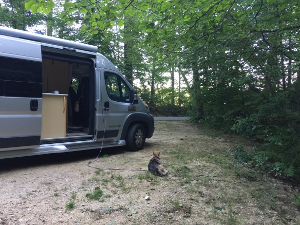
Fortunately, a cute couple in Oregon was ready to start where I’d left off and purchased Ramsey from me. I put 2/3 of the cash back in the bank and used the rest to purchase Ramsey Junior, a ProMaster City cargo van – the passenger wagon version.

I did a lot of planning before making that purchase.

  • I took all the items that I had had in Ramsey that I thought I would need in a small campervan and placed them in a pile in the middle of my garage.
  • I put the smallest items in 11″ x 17″ plastic tubs that I could stack.
  • I obtained measurements for self-inflating mattresses from the Internet.
  • I got measurements for the cargo spaces in Ram ProMasters, Ford Transits, and Nissan cargo vans.
  • I marked the spaces out in my garage and made mock-ups of how everything would be placed in that space.
  • I measured myself sitting to see how high a chair could be and not cause my head to bump the ceiling.
  • I drew plans using Adobe Illustrator.
  • I test drove the ProMaster and the Transit and lay down in the backs of both to see how well I fit.

Promaster-City-Wagon-Layout

I took a few practice trips in my much-more-cramped BMW X1. That helped me eliminate more stuff I didn’t need. I watched countless videos about van conversions to see what other people found important. (It is amazing how some couples actually live full time in tiny vans. One couple packs a water heater and a stove in the ProMaster City!) I do not live full time in my van, and I place elbow room high on my priority list.

RamseyDrivewayFacingDown

My goal is to be able to live off the grid for a week at one time. I’ve made the decision to stay with a cooler instead of a 12-volt fridge, which would need some sort of power. I can charge my phone, my computer, and my LED lantern while driving. But what if I am in one place for a week? Do I need to buy one of those self-contained batteries, like the Jackery, and a solar panel? I’m still working that out.

Meanwhile, here is a video showing Ramsey Junior so far. I have taken several weekend trips in him and been very comfortable. Let me know your thoughts.


Happy New Year 2019

I hope everyone enjoyed the holiday season. I spent Christmas with my son and his family in the Bay Area, then headed south to Pasadena for a few days to open more presents with my daughter, her husband, and their two energetic sons. From there I drove to the California desert to explore a part of my state that was too hot to be in when I drove through last September. Here is the link to my YouTube video.

By the way, for those of you didn’t get the memo, I set up a new YouTube channel so that I could have one for my personal/writing vlogs and another for my RV travel vlogs. This video is on the “Rambling in Ramsey” channel. The other channel is simply called “Mary Ames Mitchell.”

If you don’t feel like watching a video, here are the pretty pictures. The first two are of North Shore on the Salton Sea. I wish you could hear the seagulls.

6876-saltonsea

6878-saltonsea

I think this next one is of Slab City. I didn’t realize I missed that eccentric town until it was too late to backtrack.

6885-slabcityithink

I spent the night boondocking at a BLM (Bureau of Land Management, i.e. free) camping area called American Mine Road.

yumatripmap

Then drove around Yuma, Arizona the next morning. I also bought gas there. Gas in Arizona is a dollar cheaper per gallon than in California.

6908-yumaarizona

From Yuma, I cruised through sand dunes swarming with zooming dune buggies. It looked like fun.

6893-roadtoyuma

Then through the Anza-Borrego Desert.

6929-anzoborregodesertentrance

6933anzoborregodesert

6941anzoborregodesert

And through Julian, elevation 4000 feet (so check out the snow). There was no place to park, so I couldn’t pull in and walk around as I had planned.

6946julianca

I spent the night at the Vail Lake RV Resort in Temecula. Very nice.

6954vaillakervresort

Here is the view from my van the next morning.

6951temeculahills

A lovely, peaceful place to enjoy a cup of coffee. Annie liked it too.

USA Swing Videos – Pasadena to Vermont to Maryland to Pasadena

Brochures for the National Parks I saw on my westward leg of my USA Swing

Traveling westward, I visited 5 National Parks, 3 National Historic Sites, 5 National Monuments, 1 National Recreation Site and 1 National Historical Park as well as county and state parks.

I’ve just posted on to YouTube my video’s of my August to September USA Swing. In the second video, I included a clip about how I found free or inexpensive campsites using an app called AllStays.

Here are the links. The video for the trip eastward takes about 12 minutes and the video for the trip home is 33 minutes. I love it when people leave comments on YouTube and subscribe to my channel.

I feel so lucky to have been able to see our spectacular county this way. Next time I take this trip, I will make it in October and November when it is cooler.

Back to California


A map of my 2018 swing around the USA.

Green dots indicate destinations that are part of the National Parks system. Red dots indicate cities I visited for family reasons.

It’s great to be back to the land of In-n-Out Burger, though I haven’t had one yet. From Pasadena to Pasadena, my Swing Around the USA took 38 days and 37 nights. If you count San Rafael to San Rafael, I will have been away from home 48 days and 47 nights. For the purposes of this blog, here are some statistics from the Pasadena to Pasadena loop:

The number of miles driven: 8733
The number of gallons of gas burned: 475
The cost of 475 gallons of gas: $1421
The cheapest gas was in Texas at 2.39/gallon.
The most expensive gas was in Blythe, California at 3.89/gallon
The average amount spent on campgrounds: $16/night
The number of animals I saw as roadkill: 3 beaver, 1 snake, 1 deer, and 6 armadillos —I got the impression that armadillos move slowly — plus countless opossums, raccoons, and squirrels.
I saw only 1 bear. He/she was alive.
The amount spent on propane: $6.95
The number of cans of iced Arizona Green Tea I drank: 15
The average amount spent on food per day: $16

My last set of tours included the ancient American native sites in Arizona. There are a lot of them. I only saw the National Monuments of Wupatki, Walnut Canyon, and Montezuma’s Castle.

American Indians in the Four Corners region

American Indians in the Four Corners region

The Wupatki lived north of today’s Flagstaff, elevation 7000 feet, surrounded by volcanos.

Here is a rendering of what archaeologists think the place looked like 900 years ago.

Their civilization was nearly wiped out when the Sunset Crater volcano erupted. The volcano is its own national monument (i.e. another stamp on my National Parks Passport).

The photo above is of some of the hills still covered in cinders.

Within the city limits of Flagstaff, I arrived at a narrow, deep gorge called Walnut Canyon, where from as far back as a thousand years ago people lived in caves.

My final stop was Montezuma’s Castle.

I remember seeing it when my parents took my two brothers and me on a road trip to Santa Fe in 1964. My family was allowed to walk around the ancient ruins, which have since been closed off to the public because they were being worn away. The park built a model of a cross section showing what the castle might have looked like.

Annie was allowed on the quarter-mile path to see the castle. Fortunately, the path was shaded with sequoia trees. It was 100 degrees out and I had more desert to drive through to get back to Pasadena. When my family drove to Santa Fe back in 1964, we followed Route 66. There are many remains of the old route along today’s Interstate 40. I wanted to spend my last night in Quartzsite, Arizona, which I had heard about. But I couldn’t reach it before dark. Instead, I watched my last desert sunrise from a Rest Stop.

My final drive through the desert the next morning was lovely.

The entomologists at the Smithsonian would envy Ramsey’s bug collection. There are bug splats from 28 states. Now I get the challenge of washing them off.


Indian Territory

Back to having fun. Near Santa Fe, New Mexico, I came to Pecos National Historic Site, where stands the foundations of a pueblo and a Spanish church built in 1690. Underneath those structures, and in surrounding excavations, archaeologists have unearthed evidence of people living in this key geographic area for over 9000 years — hence the site’s preservation by the National Parks and why Santa Fe grew up near by.

With my brain packed with the area’s history, I drove on to the charming Santa Fe itself. I’ve been there before, but it’s amazing how different the experience is driving to a place knowing its historical and geographical significance versus arriving by train or plane.

I walked around the plaza looking for a coffee shop (my jewelry box is already stuffed with silver jewelry, so shopping was of no interest) and settled for a cookies and cream ice cream cone. Annie was allowed in the shop. She’s great at meeting people for me. While slurping, I chatted with the couple sitting next to me. They were also from the San Francisco Bay Area.

There was still enough time to head south again to Albuquerque to see the Petroglyph National Monument. The Visitor Center is in the center of the park, but not within walking distance of the petroglyphs. Since it was still too hot to leave Annie in the car, I decided to check into the nearby High Desert RV Park and tour the old Route 66. I would return to the trails when it cooled. Then some dark clouds arrived and suddenly it was pouring rain out.

I realized I loved my dog more than I loved petroglyphs. I will return to see the petroglyphs when I’m dogless.

Next was a second badlands National Park known by the Spanish word El Malpais. The park is basically a huge sea of lava (3.5 million years old) surrounded by sandstone cliffs (150 million years old). I drove down one side then the other, which took about two hours.

Gorgeous.

Then I backtracked ten miles to see the Indian Pueblo called Sky City. As its name implies, it sits on top of a bluff. The drive up to the pueblo was worth the trip, but the museum was worthless. To see the actual pueblo, I needed to pay a large fee and leave Annie in a strange kennel for a couple hours. I contented myself with viewing the pueblo via a YouTube video.

Thank goodness the site is being preserved for history sake. The Sky City Casino helps pay the renovation bills. What counts is what was.

Heading back west again, and only 30 minutes down the road from the east side of El Malpais, and across the Continental Divide,

I reached El Morro National Monument. I loved this place. The rock “headland” creates a gate on the south side of the centuries-old east-west trail.

It also serves as a landmark for a water pool that collects at the base of the cliff.

The pool has been the drinking fountain for travelers since forever. It is 150 miles from any other water source. Indians left petroglyphs on the wall of the cliff by the pool. The Spanish explorers signed their names with the message, “passed by here.” So did the pioneers. Dates range from 1607 through the 1800s.

The National Park ranger gave me a guide that explained the history behind each inscription. For example, two pioneer sisters who signed their names continued on through the Mohave, survived a bloody Indian raid, and ended up settling in Fresno, California. One of the Spanish explorers, General Don Diego de Vargas “was here” in 1692.

You’ve got to see this place for yourself.

Moving on, I ate lunch in the Zuni Village. Roasted corn. Yum.

Crossing into Arizona, I spent the afternoon driving the 28 miles north to south through Petrified National Forest.

First the Painted Desert.

Then the petrified logs. My photos don’t do justice to any of this. The colors and the expansive vistas must be experienced in person.

I’m going to visit more ancient pueblos tomorrow. I’ve been on the road for 40 days. I’m ready to head home.

Baby Cows, a Baby Bear, and a Beautiful Bride

This vacation has been so packed with fun that my head is swimming. Or is that the heat and humidity that is making my brain fuzzy?

While in Vermont, and while the tent was going up and my-sister-in-law baked 19 wedding cakes (or was it 13?), I got some more stamps on my National Parks Passport. 35 minutes south of my brother Tom’s house, I toured the Saint-Gauden National Historic Site. S-G was a talented sculptor who specialized in bronze-casted, life-sized statues of important people like Abe Lincoln. The NHS was his home and gardens.

More fun was driving through the covered bridge each way. Ramsey is 9’3″ tall, the limit, so I stayed in the middle of the bridge. A local I met later at an ice cream stand told me this bridge is the longest covered bridge in North America.

By the following day, my other brother, Charlie, and his wife Paula had joined the menagerie. They accompanied me in visiting the much more lively Marsh-Billings-Rockefeller National Historic Park. The site includes a working dairy farm — all gold-colored Jersey cows. The best part is the nursery for the little calves. I took a ton of videos, which I’ll insert in my YouTube summary of this trip. For now, here is another still shot.

They had a terrific museum about local farming and a well-done movie about George Perkins Marsh (1801-1882), who first established the estate, Frederick Billings (1823-1890), who bought the estate from Marsh in 1869, and Laurence Rockefeller (1910-2004), who married Billings’ granddaughter Mary French.

The men never met each other. The most important thing they had in common is that they were conservationists. The grounds and house are lovely, but not as fun to see as the cows.

The wedding of my niece Megan to Tom of NYC (yes, another Tom in the family) went off without a hitch. No rain, a huge blessing since it interfered with the wedding of Megan’s parents, Tom and Marguerite, on the same knoll 32 years ago. A haze blocking the sun kept it from being too hot.

After bagels at my brother’s house and goodbyes to Megan and Tom, due to return to Thailand the next day, I headed south. It was Labor Day. I stayed in a charming RV Resort by a stream, where I was able to catch up on my laundry. (Not in the stream.) The highlight of the night was a small bear who lives nearby, raiding their dumpster at night. Apparently, there is no mommy bear anywhere.

He spent a lot of time relaxing on a large boulder across the stream from Ramsey, but not that far. He watched me with lonely eyes and I wished I could feed him but knew better.

My task for today, Tuesday, through Friday, is to visit the final 20 monuments on the Henry Knox Trail. I’ll visit five each day, ending in Cambridge. In general, the trail follows Route 20 as it crosses Massachusetts from West Springfield.

Today I first found West Springfield’s monument.

Then Springfield’s. The monument is in front of the National Armory NHS (also started by Henry Knox), so I toured that, too, and got another stamp on my passport.

Then Wilbraham.

Then Palmer.

Finally Warren.

After finding each monument, I took a photo of it, then drove to the local library and donated a copy of Henry’s Big Kaboom to the children’s department.

The Most Charming Library of the Day Award goes to the Warren Library.

I had written ahead to the libraries, so they expected me. Palmer (today) and Northborough (Thursday) asked me to perform with my ukulele. I like doing that. My goal is to educate the towns along the route so that in 2026 when the Train of Artillery is reenacted to celebrate our nation’s 250th birthday, the residents will actually know what’s happening.

Tonight I am at Wells State Park not far from Brookfield, Mass, where I start up again tomorrow. Too bad I don’t have time to see nearby Sturbridge Village.

Made It to Vermont

15 days from departing Pasadena, California, I drove into gorgeous, Vermont, where my niece is getting married on Sunday. It’s Labor Day weekend. She and her betrothed are here at her parents from their own home in Thailand. The family is gathering from all over.

USA Swing Statistics So Far

I traveled through 16 states to get here.

I toured 8 National Parks, 4 National Historic Parks, 4 National Monuments (5, if you count Scott’s Bluff, which I saw from a distance), 1 National River and Recreation Area, 1 National Historic Site, 1 National Heritage Corridor, and crossed over 1 National Historic Trail. My National Parks Passport has all sorts of cancellation stamps in it.

I spent 4 nights in RV parks, 5 nights in state parks, 1 free night in a rest area, 1 free night boondocking on public land, and 3 nights parked in front of relative’s homes.

I stopped for gas 29 times. The most I spent for gas was $3.49/gal in Bryce Canyon NP, and the least was $2.69/gal in Minnesota.

My favorite campground was Fort Robinson in Nebraska, and my favorite food was the beef with barley soup I bought take-out from their restaurant.

Best of all, I’ve made 4 new fellow-RVer friends!

Since my last post, and before leaving Buffalo, I stopped briefly in the Theodore Roosevelt Inaugural National Historic Site. It was the home of Ansley and Mary (Grace) Wilcox on September 14, 1901, where Teddy Roosevelt was staying when he learned that President William McKinley had died. McKinley had been shot by an assassin in Buffalo eight days earlier on September 6. Teddy was sworn in as the new president in the library of the house (now part of HIS National Parks) four hours after McKinley’s death.

Annie was waiting in the car, so I took a quick look around, collected the brochure, and stamped my passport.

About an hour and a half hour northeast, I reached the Women’s Rights National Historic Park in Seneca Falls, which is also along the route of the Erie Canalway National Heritage Corridor.

As it states on the placard, this is the only National Park dedicated to a movement. I was allowed to take Annie with me on the walk around Elizabeth Candy Stanton’s home.

We peeked in the windows.

And we walked to the Seneca River below, which was, in Stanton’s day, part of the canal system.

The Visitor’s Center is across the river in the old industrial town of Senaca Falls, named after the Senaca Indians who once lived there. But, as you can see from my dashboard , it was 98 degrees out. (You can also see that Ramsey passed his 20,000 mile mark.)

Dogs are not allowed in the National Parks Visitor Centers, so with the car still running and air conditioner blasting, I dashed into the center to stamp my passport, collect the National Park brochure, and snap this photo of a tour going on that I had to miss. You can barely see the ranger guide behind the suffragettes.

I drove through the next town over from Senaca Falls, Waterloo, to see (through the van window) the homes of Mary Ann M’Clintock and Jane Hunt. Annie wasn’t welcome in the Waterloo Memorial Day Museum either, so we skipped that in favor of a chocolate mint ice cream cone.

Then traveling I-90, which follows the Erie Canal as it heads to Albany from Buffalo, we headed to Fort Stanwix National Monument. The fort used to guard the stretch of land between Lake Ontario and the Hudson River, waterways important from the earliest fur trading days, and even before by the American Indians. Traders used to carry their canoes and other boats from the lake to the river, hence the land was considered a portage. Eventually the city of Rome, New York, grew around and over the fort. Like its namesake, all roads led to Rome, and it was the center of the Empire (State).

110 miles due east, I arrived at Saratoga National Historic Park on the corridor of the Hudson River. I had driven past it last June when I followed the Henry Knox Trail. Henry’s Train of Artillery passed by Bevis Heights, where the park is, in December 1776. The Battle of Saratoga, during which Benedict Arnold took a lead role, occurred in September 1777. The park consists of the visitor center and the battlefields. The road through the latter was closed for repair. Missed that. But it was cool enough to leave Annie in the van so I could watch the movie about the battles and see the exhibits in the visitor center.

A five-year-old boy overheard me ask one of the rangers if many visitors to the park were also following the Henry Knox Trail. The boy ran to his parents who then informed me that the lad was a huge fan of Henry Knox. The family was indeed in the middle of following the Henry Knox Trail (even using the same guide I used in June from the Hudson Valley Foundation), had visited the Henry Knox Museum in Thomaston Maine, and bought my book. The young boy has been driving his parents crazy with the Kaboom chorus just as my four-year-old grandson has been driving his parents crazy.

How fun to have a fan!

I gave a copy of Henry’s Big Kaboom to Saratoga NHP. Who knows? Maybe they will add it to their bookstore.

Here is the view of the battlefield. Beyond that is the Hudson River, and beyond that are the Green Mountains.

I made it to my brother’s in Vermont in time to interrupt dinner with the in-laws-to-be. I parked Ramsey across the street on the lawn of an abandoned house, made myself a bean and cheese quesadilla, and opened my last Corona. What a great trip it has been had so far.

Pokagon and Cuyahoga

As I write, I’m parked in front of my baby brother’s house in Buffalo, where I spent the night. Trouble is, my brother is missing. He and his wife were delayed in Toronto so I won’t catch up with them until the wedding of our niece this weekend. Now to this blog.

After leaving my rellies in Minnesota, I spent a free night in a Rest Area in Wisconsin. Here is Ramsey parked between the Big Boys.

From there I headed toward Chicago. I followed a brief wild goose chase by seeking out a Riverside Cemetery just outside the other Windy City, where I thought my great-grandfather was buried. Lesson learned – copy genealogy notes more carefully. After learning no Knowlton Ames was buried there, I did some Googling with my cell phone and learned he was buried in Rosehill Cemetery. Since that meant backtracking, and I had 1000+ miles ahead of me before the weekend, I pushed on.

In the northeast corner of Indiana, I spent a beautiful, star-covered night in Pokagon State Park. I was one of only three guests.

Then I drove into Ohio, where I found Cuyahoga Valley National Park. It is just south of Cleveland. Whereas Arches NP is known for its rock formations and Rocky Mountain NP is famous for its 12000-ft-high drive, this NP is meant to preserve the history of the era of the Erie Canal. The hour or so drive up the valley follows an old canal, now mostly grown over, and the towpath, now manicured as a hiking or biking trail. Fun to see was the old lock.

Cuyahoga Valley NP is also known for its waterfalls. Brandywine is the most famous (photo above). Arthritic Annie was allowed to walk the boardwalk trail with me.

I had to carry her back up the stairs, poor girl.

Today we scurry through upstate New York.

I’m in Wisconsin

It is stormy and green here in the cheese state, but gorgeous.

Since my last post, I spent a peaceful night by the lake at Split Rock Creek State Campground just east of the Minnesota border – the best site for a night in Ramsey ever.

About 15 minutes up the road, I toured Pipestone National Monument, where American Indians have mined the red stone used for peace pipes for as long as their oral tradition remembers. The red stone is thought to contain the blood of their ancestors, hence a very spiritual stone.

This reproduction of a painting by George Caitlin shows the mines in the middle of the prairie in the mid 1800s.

Then I dashed through corn field after corn field to St Paul on the other side of Minnesota to visit my third-cousin-once-removed, Leila. She turns 94 this Thursday. I spent two nights in a real bed.

On Saturday, we toured Grand Hill, where her side of our family lived for four generations, and where my paternal grandmother spent her childhood. The current owner of 501 Grand let us look around.

This morning, more of my third cousins gathered for breakfast. Here are four generations of Ameses.

Next destination, Cuyahoga Valley National Park in Ohio. I must drive through Illinois and Indiana first. I’m due in Vermont for the wedding festivities for my niece on Friday.

Wind Cave and Badlands National Parks

I’m on the 10th day of my 6-wk Swing Around the USA, which I should probably rename “Zoom Around the USA.” On travel days, I’m driving between 215 and 297 miles a day, not counting the first leg from Pasadena to Zion, which was 433 miles. I’m paying between $2.77 and $3.59/gal for gas depending on how remote I am. I thought I would boondock more, but so far I’ve had only one free night. The free view over the Grand Staircase Escalante National Monument was amazing, but I wasn’t very comfortable with the isolation. Feeling less brave, I look first for state park campgrounds, which are gorgeous and inexpensive ($12 to $24 so far), then RV Parks ($33 to $45). I’ve only had to dump my tanks once. I prefer my own coffee to anything I can buy out and eat lots of fruit and granola for breakfast. In order to eat plenty of veggies, I cook most of my dinners. Cooking and eating outdoors is a nice thing to do at the end of a day of driving and sightseeing.

Yesterday I started with Wind Cave National Park in South Dakota. It offers two highlights: The “Park” itself is a calming, preserved prairie complete with buffalo and prairie dogs.

Under the park, like a subway maze, is one of the world’s most complicated and extensive natural caves. The native Americans thought it was the Source, where buffalo came from. 436 miles have been explored so far by daring people who like crawling through dark, tiny spaces. In the 1800s, all they had were candles to guide them in, and string to lead them out. It’s thought only 20% of the network has been seen so far.

Though I overcame my fear of heights to drive the 12000-foot-high trail over Rocky Mountain NP, my even worse claustrophobia and the excuse not to leave Annie in the car too long (there was an hour wait for the Cave tour and the tour itself takes an hour) led me to the 20-minute movie in the visitor center auditorium.

To get from Wind Cave NP to Badlands NP, also in South Dakota, I wiggled through the pine-covered Black Hills in Custer State Park.

Like every National Park I have seen so far, Badlands offers sights you can’t see anywhere else in the world. The 45-mile drive through the canyons of its white mountains kept me saying “WOW”.

At the end of the drive is a campground but off limits to rigs over 18 feet. Ramsey is 20.5 feet. However, not much farther down the road is a tourist spot I’m glad I didn’t miss. The little town of Wall has two RV Resorts. The reviews on the app AllStays, which I frequently use to find places to park, praised Sleepy Hollow RV Resort, which is where we are now.

It’s very nice and friendly, and only a short walk away from the real highlight of this town, Walls Drugs, a super touristy mall of shops offering everything from cowboy boots to ice cream to BBQ beef sandwiches to silver decorate rifles.

I now have two days to get to St. Paul, Minnesota. My National Parks map says that Pipestone National Monument is about halfway.