My odometer on Ramsey just flipped to 10,000 miles. Click on the second image below to check out the YouTube video I made in celebration. As usual, don’t forget to like, subscribe and share.

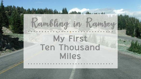
My odometer on Ramsey just flipped to 10,000 miles. Click on the second image below to check out the YouTube video I made in celebration. As usual, don’t forget to like, subscribe and share.
Pasadena is famous for the tiny cottages ‘grandfathered’ into the back of properties in neighborhoods reserved for single-family dwellings. My daughter and son-in-law do not have one of those cottages, which is why I visit in Ramsey. This time I upgraded from parking him on the street to shimmying my way up the driveway to park in the backyard. It was a tight squeeze, but worth it — quieter and a safer walk to my front door for my tiny grandsons.


Relatively recently, I became interested in early man’s efforts to communicate through rocks and rock drawings or pictographs. I had no idea how many ancient rock formations are sprinkled around New England. Some, such as the structures at America’s Stonehenge in New Hampshire, have been carbon dated to over 2000 years old. I joined the NEARA (New England Antiquities Research Association), went to one of their conferences, and learned more about analyzing, finding, and preserving these often ancient and mysterious structures.
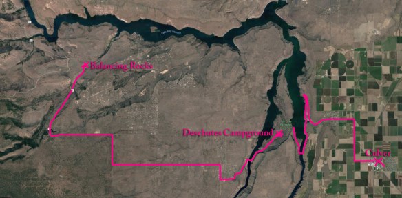
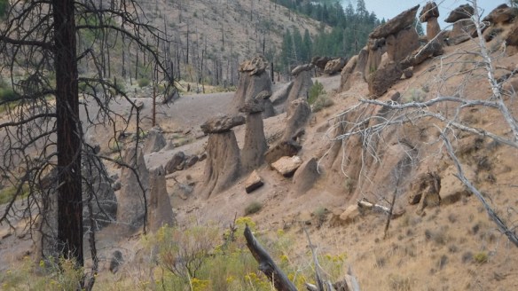
One type of rock formation common in New England is balancing rocks. When I learned there was a field of balancing rocks in Culver, Oregon, which I visited to watch the solar eclipse, I just had to see them. (They are also called the Metolius Balancing Rocks, even though you get there from Culver.) No one knows who positioned these rocks, how, or when. The National Park service has marked them on their maps, provided detailed instructions on how to reach them from one of its campgrounds (directions inserted below), and built a path for us to walk out to see them.
Still, finding the rocks was not easy. I made many wrong turns before reaching them. I started my search by asking the locals at Culver’s coffee shop, “Do you know how to get to the Balancing Rocks?” Most of the people I talked to confused them with a structure known as Shipwreck. “They are only 20 minutes away,” they told me. Wrong. It takes 35 minutes to reach the rocks from Culver. The drive itself is an adventure.
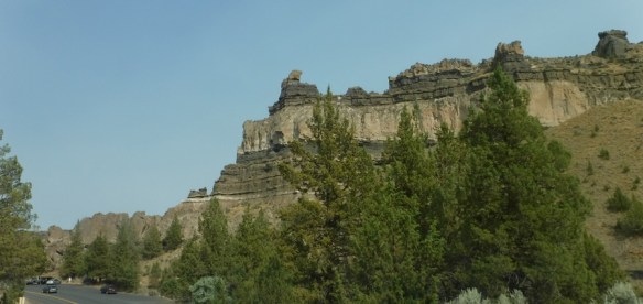
 Culver is on a vast plain. It looks flat as far as you can see. (That is Mt. Jefferson in the background.)

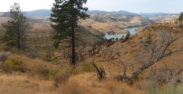
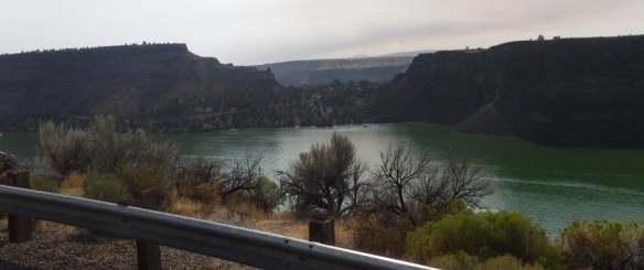
But the Crooked River (aka the Metolius River, a tributary of the Deschutes River) has cut a mini grand canyon that has two forks. After driving along the flat roads, you suddenly plunge into the canyon toward the Billy Chinook Lake, part of Cove Palisades State Park. The lake formed when people built the Billy Chinook Dam across the Crooked River. Sorry about the bug splats on my window.
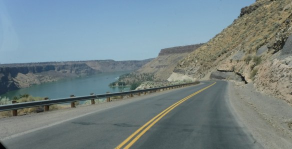
I knew I was supposed to skirt the lake for a while until I came to a bridge. This bridge had two lanes.
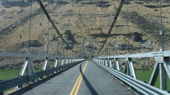
On the other side of the bridge, I skirted the lake for another quarter mile then climbed the canyon wall and came out on the land between the two forks of the lake. I wove through some low, rocky hills and came to the Deschutes Campground, where a ranger gave me the written directions I needed. From the campground, the drive is 13.9 miles west. I wound my way to the the second canyon and plunged down once again, where I crossed the fork of the lake on a single lane bridge. That meant I had to make sure no one was coming from the other direction. Or if there was a line for the bridge on the other side, I had wait for my turn. I was the only one around. Point is — this was not a well traveled road to an important tourist destination.
On the other side of the bridge, I climbed out of the canyon, then followed straight roads through flat wooded, desert and dusty land. Again, you can see Mt. Jefferson in the distance.

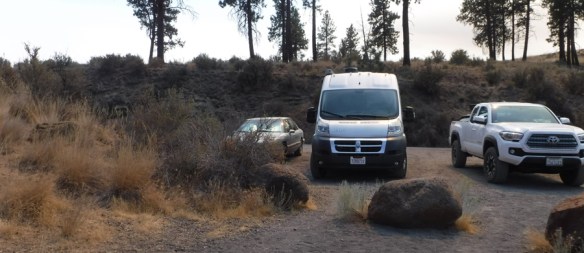
I made right angle turns, as you can see from my map above. At milage point 13.5, the pavement ended and Ramsey bumped along a gravel road going up a hill. My RV does not have four-wheel drive, but I only had .4 miles to go. I could see Road 1170 marked on the left, the only landmark that told me I was in the right place. A turnoff on the right served as a three-car parking lot, marked by the first sign I had seen saying “Balancing Rocks.”
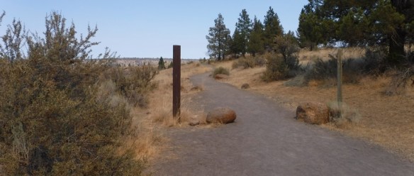
A path obediently led from the parking area. My directions told me to look for the Balancing Rocks to my left about a quarter mile down the path.
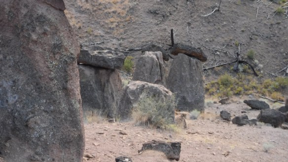
Sure enough, there they were.
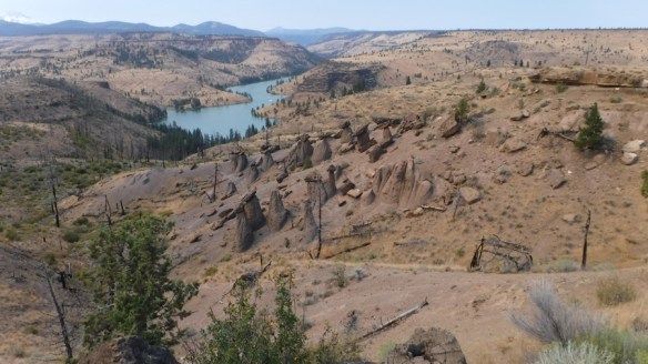
The path led to the right around the top of a ridge, from where I could climb down to the area of the rocks. I noticed from this angle that the pillars seemed to form an arrow. I checked the compass app on my iPhone and learned that the arrow pointed north. Mt. Jefferson is to the left, almost due west of the rocks. I would love to visit again during a solstice to see if the sun comes up any where near Mt. Jefferson.
Most of the balancing stones, which were shaped as rough arrow points, also pointed north. (These stones were shaped by breaking, not worn away by water.) When I reached the stones, I walked around with my copper divining rods, but I’m not very experienced at using them and they didn’t make any interesting movements.


These next four photos were taken on the other side of the ridge from the main cluster of stones.


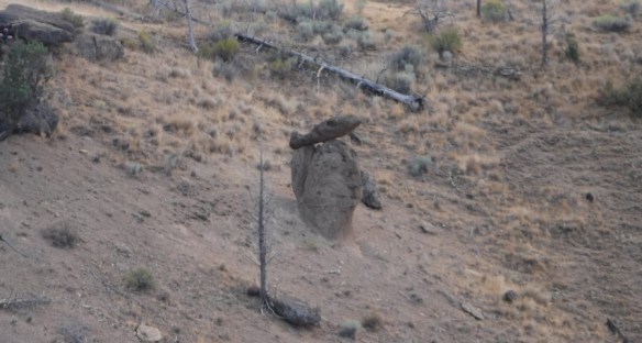

Faithful hound, Annie, waited patiently while I snapped pictures. The photo of her gives you a close up of the rock bed. The balancing rocks seemed to be of a darker stone than the pillars on which they balanced.

Time to go home. I followed the path back along the ridge away from the stones.

I took these two photos from the path along the ridge as I walked back to the parking area, the second by zooming in.
On the way back to Culver, I passed the rock formation that I assume is called Shipwreck Rock. It is indeed about 20 minutes from Culver.
I climbed back up the canyon after crossing both bridges again. From this point, I could see one canyon from the other.
I crossed the RR tracks as I returned to Culver.

One web article stated that the rocks were for a long time hidden from the public even though the National Forest Service rangers knew about them. A forest fire in 2002 revealed their existence to the public. That same article stated, “The rock spires were created by one volcanic eruption, while the balancing slabs on top were created by others. Because of their differing sedimentary make-up, the rocks eroded at different rates.” After studying the New England balancing rocks, I don’t believe that statement for a minute. I think people purposefully created these structures to state a message, which probably has something to do with the agricultural calendar and the celestial bodies.
If anyone reading this can support my claim, I would love to hear from you.
Here is a website about other balancing rocks around the world:
http://www.waymarking.com/cat/details.aspx?f=1&guid=4480cfa2-58a5-40b0-9a18-14811fc24a3a&st=2
As promised, here are the directions to the Balancing Rocks from the Deschutes Campground — as given to me by the State Park Ranger service. These structures could have been formed by man thousands of years ago. Help us preserve them.
Essentially, you follow the main paved road for the first 13.5 miles. It turns to gravel for the last .5 mile. It is passable by passenger vehicles, although it includes steep curves. Easy parking is available for two passenger vehicles (not trailers). Allow 1/2 to 1 hour driving time one way.
Mile 0 – Turn left out of the campground onto Jordan Road, proceed to the Deschutes Bridge.
Mile 1.5 – Carefully proceed across the one land bridge and follow Jordan Road to the top of the canyon.
Mile 5 – Bear right to stay on the main paved road.
Mile 7.1 – Pass the Three Rivers Recreation Area on the right.
Mile 10.5 – You will enter the National Forest Land. Stay on the paved road. You will see evidence of forest fire.
Mile 13.5 – The pavement ends.
Mile 13.8 – Road 1170 will head off to your left. Continue on your path.
Mile 13.9 – Take the first turnoff to the right. This is the parking area for Balancing Rocks.
Park your can and hike about 1/4 mile down the dirt path. Look for the Balancing Rocks on your left.
Have fun and stay safe.
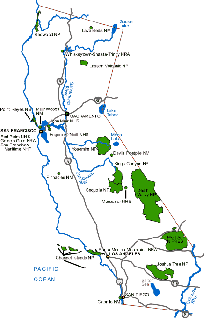
Hi. I’m back from a week visiting my grandchildren (the three-year-old loved Ramsey) and ready to plan out how I will visit all the national parks in the continental US during the next ten years. We’ll start with my home state, California. Here is a map put out by the park services that I found online.
And here is my checklist based on the map above.
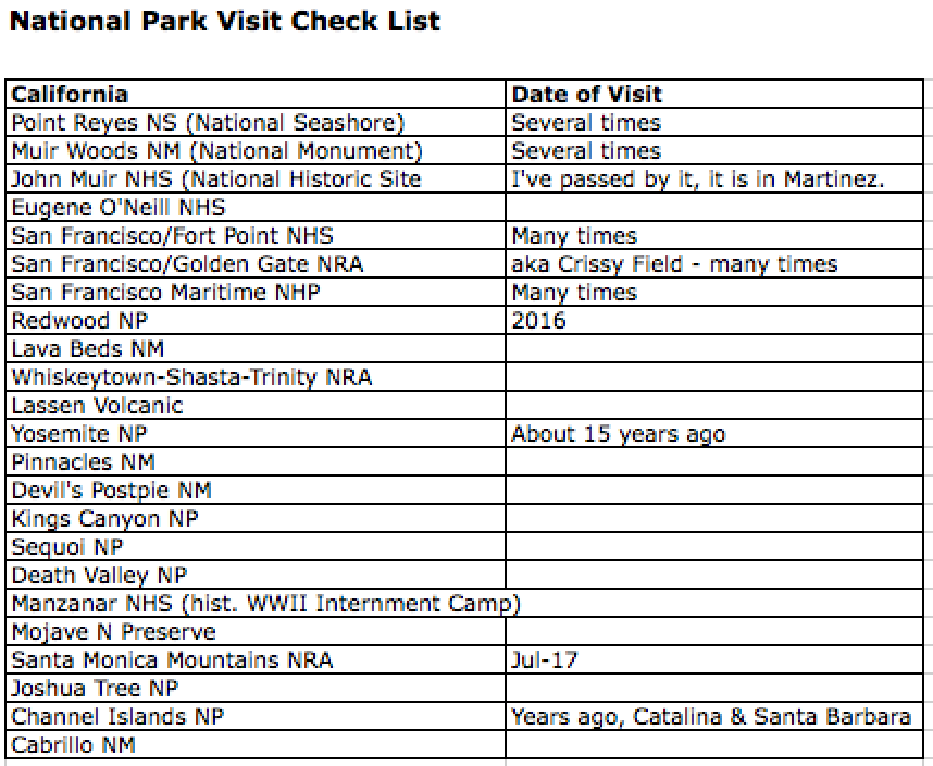
Just compiling the list was educational. I’d never heard of Manzanar. Next step is to visit the Muir Woods, which I’ve been to, and which is close to me. The purpose is to obtain a Senior Pass for the National Parks. It is my understanding that the wait time for purchasing one online takes several months and this will take a few hours, plus give me a nice outing. The hard part is finding places to stay during the busy summer season.
Three days ago I decided to become an RVer. I drove an hour and a quarter from San Rafael, California, to Davis near Sacramento to see an Agile. Really cool, but very claustrophobic inside.
Yesterday I drove to Sacramento again. This time to test-drive a Pleasure-Way Ascent – same Mercedes chassis and motor, different cabin makers – all 19 feet 7 inches of it. I loved it. My corgi Annie will love it, too. [She didn’t go with me because it was too hot.] On the way home, I stopped by AAA and obtained a book on camping in the ‘extreme west.’ When I get the hang of the extreme west, I may skip over the not-so-extreme west, which is mainly desert. I want to finally visit Yellowstone National Park. I want to camp by one of Minnisota’s thousand lakes.
I found an old notebook and began My RVing Diary. I spent my evening in Google bliss gathering information on how to outfit an RV. How and where to dump the waste from an RV. Learning the difference between green water, blue water, gray water, and black water. I found all sorts of videos of people traveling with their dogs. People cooking gourmet meals in their teensy-tiny kitchens. People enjoying the sunrise from atop America’s precipices while sipping an RV-brewed cup of espresso.
I had already made up my mind I preferred traveling alone than with anyone I know.[Actually, there is one exception, but he is not available.] I turned 65 this year, the age I remember my grandmother being. My hands look like hers, with blotches all over them and veins protruding like the roots of a camphor tree breaking the sidewalk. My last marriage ended 21 years ago. My efforts at trying to find someone to have fun with and travel with have introduced me to some wonderful people. But the reality is…
My grandmother said she took up golf when she turned 65. My grandfather took another two-month trip to the Far East. My mother went to China with my step-father. My father wasn’t speaking to me when he turned 65. If you’ve read my book about him, I think you will agree he was probably in no position to do anything fun.
I’d rather spend my leisure time writing than playing golf, or sitting under a massive umbrella on a beach in Hawaii, or, heaven forbid, taking a cruise. Like my grandfather and my mother, I’m a hermit by nature, though I do feel lonely most of the time. Now I imagine myself writing in my Ascent while it is parked along the Avenue of the Giants, or by Old Faithful, or how about on the banks of Niagara Falls?
America, here I come. But I have to gather some pocket-change first.
